The recent discovery of a Roman-era shipwreck at a depth of 2,500 meters off the coast of France is not just a win for marine archaeology. It is a loud signal that the last inaccessible frontier on our planet is finally open for business. For decades, the abyss was a graveyard protected by physics. The sheer weight of the water column crushed anything but the most expensive, government-funded submersibles. Now, a new generation of autonomous underwater vehicles (AUVs) and remotely operated vehicles (ROVs) has turned the tide.
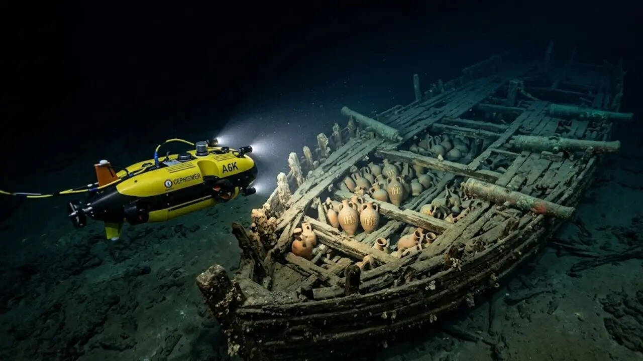
This specific wreck, found within the French Exclusive Economic Zone, sits in what oceanographers call the bathypelagic zone. At 2.5 kilometers down, the pressure is roughly 250 times that of the surface. To put that in perspective, it is like having an elephant stand on your thumb. Finding a wooden hull and its cargo of amphorae intact at this depth is an achievement of precision engineering, but it also raises uncomfortable questions about who owns the past and who has the right to strip it for data or profit.
The Engineering of the Abyss
Finding a needle in a haystack is easy when you can see the hay. Finding a shipwreck in the deep Mediterranean is more like trying to find a specific grain of sand in a dark room using only a laser pointer. The French team utilized high-resolution side-scan sonar and multi-beam echo sounders to map the seafloor. Unlike traditional surface-based mapping, these sensors were mounted on an underwater drone that flew just meters above the silt.
Traditional underwater exploration relied on "mowed lawn" patterns. A ship would sail back and forth, dragging a sensor on a long cable. The lag was immense. If the sensor saw something interesting, the ship was already two kilometers away by the time the signal reached the surface. Modern AUVs are different. They are pre-programmed with artificial intelligence that allows them to recognize anomalies in real-time. If the drone spots a shape that doesn’t look like a rock, it can deviate from its path, hover, and take high-definition photographs without a human ever touching a joystick.
The equipment used in this discovery represents a shift from "dumb" mechanical tools to "smart" sensors. The cameras must withstand freezing temperatures and immense pressure, requiring sapphire crystal lenses and titanium housings. Lighting is the biggest hurdle. Water absorbs light rapidly, meaning these drones must carry massive battery arrays to power LED banks that can cut through the eternal dark.
Beyond the Wood and Clay
Why does a pile of 2,000-year-old jars matter in 2026? The answer lies in the state of preservation. In shallower waters, shipwrecks are ravaged by wood-boring worms, light-induced decay, and the relentless churning of storms. At 2,500 meters, the environment is a vacuum-sealed vault. The oxygen levels are lower, the temperature is a constant four degrees Celsius, and the "shipworm" (Teredo navalis) cannot survive the pressure.
This means we aren't just looking at a wreck. We are looking at a snapshot of Roman logistics that has been frozen in time. The amphorae found at this site likely contain residues of wine, olive oil, or fish sauce (garum) that have not been contaminated by modern biological activity. For a historian, this is the equivalent of finding a hard drive from the first century.
However, the technology that allows us to see these treasures also allows us to take them. The debate in the archaeological community is currently split between "in situ" preservation and recovery. Some argue that these sites should be left alone, treated as underwater museums. Others point out that as deep-sea mining and telecommunications cable laying expand, these sites are in more danger than ever. A plow for an internet cable doesn't care if it's cutting through a reef or a Roman galley.
The High Cost of the Deep
One cannot ignore the economics of this discovery. The daily operating cost for a vessel capable of deploying 3,000-meter-rated drones can exceed $50,000. This isn't a hobby for the lone treasure hunter in a rickety boat. This is the domain of massive state institutions like France’s DRASSM (Department of Underwater and Submarine Archaeological Research) or private energy companies.
There is a growing friction between academic research and commercial interests. The same drones used to find this shipwreck are used by oil and gas giants to inspect pipelines and by mining companies looking for polymetallic nodules. As the technology becomes cheaper and more accessible, the "hidden world" will become crowded. We are entering an era where a private entity could theoretically locate, map, and loot a deep-sea wreck before a national government even knows it exists.
The legal framework is lagging. The UNESCO Convention on the Protection of the Underwater Cultural Heritage provides some guidelines, but enforcement at 2.5 kilometers depth is virtually impossible. You cannot station a police boat over a spot in the middle of the ocean for three years. If a drone can dive, grab a gold coin, and return to a stealthy support ship, the crime is invisible.
The Reality of Remote Discovery
There is a romanticized version of this story where a scientist looks through a porthole and screams "Land ho!" That is a myth. The reality is a group of technicians sitting in a darkened shipping container on the deck of a rolling vessel, staring at grainy blue-and-gray monitors. They spend hours looking at static.
The discovery happens in the post-processing. It's only when the terabytes of data are run through photogrammetry software—which stitches thousands of 2D images into a 3D model—that the shipwreck truly "appears." We are no longer discovering things with our eyes; we are discovering them with algorithms. This shift changes the nature of the find. It becomes a data set before it becomes a physical object.
Moving Toward a Transparent Ocean
The French discovery is a proof of concept for a new era of maritime sovereignty. By mapping the deepest parts of their waters, nations are effectively planting a flag on the seabed. It is as much about geopolitics as it is about pottery. Understanding the topography and the contents of the deep Mediterranean is a prerequisite for controlling it.
As we look further down, the challenges scale exponentially. We are currently comfortable at 3,000 meters. The average depth of the ocean is nearly 4,000 meters. The "hadal" zones, the deep trenches, go down to 11,000 meters. Each thousand meters requires a complete redesign of the electrical and structural systems of our robots.
The true value of this deep-sea Roman wreck is that it forces us to decide what we want the ocean floor to be. Is it a historical archive to be protected? Is it a resource to be mined? Or is it a tactical theater for the next generation of sub-surface surveillance? The drones are already there, and they aren't waiting for us to make up our minds.
The next step is not just finding more wrecks, but establishing a digital registry of the seafloor that is updated in real-time. We need a "Google Earth" for the abyss that tracks every anomaly and every movement. Without a transparent, shared map of the deep, the most significant sites in human history will be lost to the shadows of the very technology meant to find them.
Check the live telemetry feeds from the next DRASSM expedition to see how the mapping software handles the silt plumes of the deep.